Showing posts with label How To. Show all posts

How To Subscribe To DrillingMaps.com Database

How to Subscribe

Subscribing to DrillingMaps.com is simple:

  1. Visit the DrillingMaps.com website.
  2. Use your Google account to sign in and start accessing the comprehensive refinery health and safety database immediately.

Affordable Pricing

  • $0.03 Per Day
  • $1 Per Month for access to the Map Database
  • 7-Day Risk-Free Trial: Try it out with no obligation and cancel anytime

๐Ÿ’ฅ All-Access Map Bundle: 22 Maps for $9.95/month

Syndicated Maps bundled subscriptions

Syndicated Maps has recently launched a value-packed bundled subscription that gives users access to all 22 of its niche maps for just $9.95 per month—a savings of over 50% compared to subscribing individually. This all-access plan was created in response to user demand for a more affordable way to explore multiple data layers across traffic enforcement, environmental hazards, wireless coverage, energy infrastructure, and public safety. Whether you're a researcher, commuter, traveler, or concerned homeowner, this bundle lets you seamlessly tap into detailed, location-based intelligence from across the entire network.

Each map serves a specific purpose—from helping drivers avoid speed traps to alerting families about nearby environmental hazards. The Syndicated Maps network has earned the trust of millions of users annually, including commuters, journalists, health professionals, and urban planners. 

Why Subscribe to DrillingMaps.com? 

Are you in the oil and gas industry and prioritize safety and compliance?  Are you looking to move to a new residential location and want to learn about a particular area that might have oil and gas drilling in the neighborhood?   DrillingMaps.com offers a comprehensive Health and Safety Map Database that ensures you stay informed and compliant at all times. Here’s why subscribing to our service makes perfect sense:

1. Comprehensive Coverage: Our Health and Safety Map Database provides extensive coverage of drilling sites, ensuring you have access to crucial safety information wherever your business operations or residencies take you.

2. Real-Time Updates: Stay ahead with real-time updates on regulatory changes and safety measures relevant to your operations. Our database is constantly updated to reflect the latest information.

3. User-Friendly Interface: Easily navigate through our user-friendly interface designed for quick access to essential safety data. Find what you need efficiently and effectively by searching the map.

4. Cost-Effective Pricing: We believe safety shouldn’t come at a premium. Subscribe for just 0.03 cents per day or $1 per month to gain access to invaluable safety resources that protect your family and workforce.

5. Peace of Mind: With DrillingMaps.com, you can move to a new area and not wonder what might be going on that wasn't disclosed to you in the disclosures.  

Smell Gas In or Near Your Home? Here's What to Do

Smelling gas in or around your home is a serious safety concern. Whether it’s natural gas, propane, or methane from a nearby source like an abandoned oil well or pipeline, taking immediate action can save lives and prevent disasters.

๐Ÿšจ First, Act Fast – Safety First

If you detect a rotten egg or sulfur-like smell, it could be a gas leak. Here's what you should do immediately:

1. Evacuate the Area

Leave your home or the affected area without turning lights on or off, using appliances, or touching anything that could cause a spark.

2. Do Not Use Electronics or Phones Indoors

Cell phones, light switches, or even garage door openers can trigger explosions. Wait until you’re safely outside to make any calls.

3. Call 911 or Your Gas Utility Emergency Line

Report the smell to emergency services or your local gas company right away. Most major gas providers have 24/7 emergency response teams.

4. Warn Neighbors If You Can

If it’s safe, alert others in nearby homes, especially if you're in an apartment or condo.

๐Ÿ›  Common Sources of Residential Gas Smells

Gas odors can come from multiple sources:

Knowing the source can help guide next steps, but do not investigate leaks yourself. Leave that to trained professionals.

๐Ÿงช When It's Not the Stove: Underground or Environmental Gas Leaks

Many homeowners live near old oil wells, underground pipelines, or natural gas storage sites without realizing it. These can leak methane into basements, crawl spaces, or even the air around your home.

✅ How to Check:

๐Ÿ”ง After the Leak: What Comes Next?

Once authorities have resolved the immediate danger:

๐Ÿงญ Preventive Tips for Homeowners

  1. Get annual inspections for all gas-powered appliances.

  2. Know your surroundings—especially if you live near drilling sites or old infrastructure.

  3. Install methane/gas sensors in low-lying areas like basements.

  4. Seal foundation cracks to reduce entry points for gas vapors.

⚠️ Don’t Ignore That Smell

Even a faint gas odor deserves your full attention. Leaks can lead to explosions, fires, or long-term health issues from chronic exposure. Stay safe, act fast, and know where to get help.

๐Ÿ” Related Searches People Are Asking:

  • What does natural gas smell like?

  • Can a gas leak kill you?

  • How far does gas travel underground?

  • Who to call for a gas smell outside?

  • Are abandoned oil wells dangerous?

Want to check if you're near a leaking well or old pipeline?
Visit DrillingMaps.com to search your address and explore safety data near you.

Is There Oil or Gas Drilling Near Your Home?

Worried about oil or gas drilling in your neighborhood? You're not alone. An estimated 17 million Americans live within a mile of at least one active oil or gas well, and millions more live near abandoned or orphaned wells. These sites can pose serious environmental and health risks, often without residents realizing it.

In this guide, we’ll show you how to check for nearby drilling, break down the potential dangers, and give you specific action steps and tools to protect your family and property.

Why You Should Be Concerned

Oil and gas wells—especially the estimated 3.7 million abandoned wells across the U.S.—can leak methane, volatile organic compounds (VOCs), benzene, and other hazardous substances. These emissions can:

  • Contaminate groundwater and soil

  • Trigger asthma and respiratory illnesses

  • Increase the risk of fire and explosion

  • Reduce property values by 10% or more in affected areas

In Los Angeles, over 100 abandoned wells in Playa Vista were found leaking toxic gases into residential neighborhoods. In Pennsylvania, hundreds of thousands of abandoned wells remain uncapped, many dating back over a century.

5 Reliable Tools to Check for Nearby Drilling

1. FracTracker Alliance

FracTracker.org features national and state-specific interactive maps that display both active and abandoned wells. California residents can use their maps to see well emissions and proximity to schools or homes.

๐Ÿ“ Over 3,000 active wells are located in Los Angeles County alone.

Visit: https://www.fractracker.org

2. Houston Chronicle – Orphan Wells Map

A Texas-focused tool showing the location of more than 8,200 orphaned wells as of 2023. Just input your address to check your proximity.

๐Ÿ›ข️ Texas is home to over 440,000 active wells and tens of thousands of inactive ones.

Visit: https://www.houstonchronicle.com/projects/2023/orphan-wells-searchable-map

3. Grassroots Coalition – Playa Vista Well Map

For Los Angeles residents, this tool highlights over 100 known abandoned wells beneath Playa Vista. Many have tested positive for methane and hydrogen sulfide leaks.

⚠️ A 2022 report linked leaking wells to indoor air pollution levels exceeding safe thresholds.

Visit: https://saveballona.org/content/map-abandoned-oil-wells

4. NPCA – Orphan Wells Near National Parks

The National Parks Conservation Association mapped over 30,000 orphan wells within 30 miles of national parks.

๐Ÿž️ These wells are polluting park air and water—posing a threat to both ecosystems and nearby communities.

Visit: https://www.npca.org

5. Earthworks – Pennsylvania Oil & Gas Waste Map

Pennsylvania has over 129,000 active wells and as many as 560,000 abandoned ones. Earthworks.org offers a robust map and database tracking these wells and the associated waste sites.

๐Ÿงช This data shows connections between oil and gas activity and drinking water contamination.

Visit: https://earthworks.org/resources/pennsylvania-oil-gas-waste

Action Steps to Protect Yourself

  1. Search Your Address using tools above to identify nearby wells.

  2. Contact Local Authorities or your state’s oil and gas commission for detailed site data.

  3. Request Public Records on mineral rights and drilling permits before buying a home.

  4. Install Methane and VOC Detectors if you live within a mile of any wells.

  5. Join Community Boards or Environmental Groups to stay informed and advocate for cleanup.

For added security, request a professional environmental site assessment (ESA) if you suspect drilling activity near your property. 

Detect Abandoned Oil Well Leaks Near Your Home

Abandoned oil wells are more prevalent than most people realize, especially in oil-rich states like Oklahoma, Colorado, Texas, and California. Once thriving oil fields, many urban areas now conceal thousands of inactive wells, some improperly sealed or entirely forgotten. These wells can pose significant environmental and health risks by leaking harmful gases and contaminants. Here’s how to detect a leaking oil well near your home and what actions can be taken.

Understanding Abandoned Oil Wells

An abandoned oil well is a well that is no longer in use and has been sealed or left idle. However, if improperly sealed, these wells can emit methane, volatile organic compounds (VOCs), and other hazardous substances. In urban areas, the threat is especially concerning, as residents may be unaware of nearby wells.

How to Identify a Potential Oil Well Leak Near Your Home

  1. Check Official Maps and Databases: States like Texas, Oklahoma, and California have public maps of abandoned wells. The EPA and state environmental agencies provide searchable databases to locate wells near residential properties.

  2. Look for Visible Signs: Signs of a leaking well may include dead vegetation, discolored soil, a strong petroleum odor, or unusual bubbling in nearby bodies of water.

  3. Monitor for Gas Leaks: Methane leaks can be detected using specialized sensors. In some cases, state agencies may conduct air quality testing in areas known for historic drilling activity.

  4. Inspect Property Records: Older homes, particularly those in oil-boom cities like Los Angeles, Houston, and Denver, may have historic records indicating proximity to former drilling sites.

Examples of Abandoned Oil Wells in Key States

  • Oklahoma: Oklahoma City is dotted with thousands of old wells, some of which are improperly sealed. In 2021, a leaking well near a residential neighborhood emitted methane, triggering a response from state regulators.

  • Colorado: In 2022, residents in a Denver suburb reported strong gasoline-like odors, which were traced back to an improperly capped well. The state’s Oil and Gas Conservation Commission intervened to remediate the site.

  • Texas: Houston, once an oil boomtown, now has numerous abandoned wells beneath residential developments. In 2023, a leaking well in a low-income neighborhood was found to be emitting methane and VOCs, raising environmental justice concerns.

  • California: Los Angeles is built atop thousands of historic wells. In 2019, a leaking well in South Los Angeles led to complaints of headaches, nausea, and respiratory issues among residents, prompting calls for stricter regulation.

What Has Been Done in the Past?

Efforts to address abandoned wells include federal and state-funded well-plugging programs. The Bipartisan Infrastructure Law allocated $4.7 billion to plug orphaned wells nationwide. States like California, Texas, and Oklahoma have established similar programs aimed at locating and capping wells to prevent leaks.

What You Can Do

  • Report Suspected Leaks: If you suspect a leak near your home, contact your state’s environmental protection agency or the EPA.

  • Request Testing: In some states, residents can request air and soil testing for potential contaminants.

  • Monitor Local Legislation: Stay informed about state and local initiatives focused on identifying and remediating abandoned wells.

Final Thoughts

Abandoned oil wells can pose serious health and environmental risks, particularly in densely populated areas of Oklahoma, Colorado, Texas, and California. By staying informed and vigilant, residents can help identify potential leaks and take action to protect their health and safety.

Using Satellite Image to Find Oil & Gas Drilling Pads

Satellite View of Oil Drilling Pads

What Are Those Spots You See from Space?

How to Identify Oil & Gas Wells Using Satellite Imagery

Satellite imagery has revolutionized how scientists, regulators, and even curious homeowners understand oil and gas activity. What once required field visits and flight surveys can now be observed from hundreds of miles above the Earth. With today’s high-resolution satellites, it’s possible to identify well pads, access roads, and storage facilities — even detect signs of environmental change — simply by studying a series of images from space.


The Power of Satellite Observation

Modern satellites orbiting the Earth continuously capture detailed images of its surface. These images provide data about land use, infrastructure, and geological changes. For the oil and gas industry, this technology has become an indispensable tool for exploration, production monitoring, and environmental compliance.

Each pixel in a satellite image tells part of a story — a freshly cleared area might signal new drilling, a cluster of circular tanks could indicate a storage site, and faint lines crisscrossing the landscape may reveal pipeline routes. Analysts use these clues to map activity across vast regions, from Texas shale basins to remote deserts in the Middle East.

As imaging resolution improves — with commercial satellites now offering detail down to 30 centimeters — the ability to monitor energy operations has expanded dramatically.


What Do Oil & Gas Well Pads Look Like from Space?

To the untrained eye, a well pad may appear as a light-colored rectangle surrounded by untouched terrain. But trained analysts can recognize specific indicators:

  • Cleared or compacted land: Drilling pads are often cleared of vegetation and flattened to accommodate heavy machinery.

  • Access roads: Straight or curved dirt roads often connect multiple pads to a central route or highway.

  • Storage tanks and separators: Bright circular or rectangular shapes within a pad often indicate oil, gas, or water storage units.

  • Shadow signatures: Tall pump jacks, derricks, or rigs can cast elongated shadows, particularly noticeable in morning or evening imagery.

  • Associated infrastructure: Nearby ponds (for water or drilling fluids), flare stacks, and pipeline corridors further confirm industrial activity.

When viewed as a network, these pads form repeating geometric patterns across the landscape — a telltale signature of large-scale resource extraction.


The Role of AI and Machine Learning

Identifying thousands of well pads manually from satellite imagery can be time-consuming. That’s where machine learning algorithms come in.

By training AI models with labeled examples of known well sites, computers can learn to recognize similar patterns in new images. The process involves analyzing texture, brightness, color, and shape differences between natural terrain and human-made structures. Once trained, the system can scan entire states or countries in hours — mapping every visible well pad automatically.

AI models are also used for change detection, identifying where new pads appear or where old ones are being reclaimed. This enables regulators to detect unreported drilling and track compliance with reclamation requirements.


Who Uses Satellite Imagery for Oil & Gas Monitoring?

1. Regulatory Agencies

Government agencies use satellite imagery to enforce drilling permits, detect unregistered operations, and evaluate compliance with environmental regulations. This approach allows them to monitor large, remote areas that would otherwise be difficult or expensive to survey in person.

2. Environmental Organizations

Nonprofits and researchers analyze imagery to track deforestation, methane leaks, and water contamination around well sites. By comparing time-series data, they can show how drilling activity affects nearby ecosystems and communities.

3. Energy Companies

Operators themselves rely on imagery to plan logistics, monitor construction, and manage safety risks. Satellite data also helps verify lease boundaries and optimize land use.

4. Landowners and the Public

Homeowners and landowners increasingly use mapping tools to identify nearby wells, evaluate potential hazards, and monitor property conditions. Crowdsourced platforms, such as DrillingMaps.com, allow anyone to view, contribute, and report well locations.


How Experts Analyze Satellite Imagery

  1. Define the Area of Interest (AOI): Analysts begin by focusing on regions known for energy production, such as the Permian Basin or the Bakken Formation.

  2. Acquire Multi-Date Imagery: Comparing old and new images reveals changes — new clearings, road expansions, or pad construction.

  3. Use GIS Software: Programs like ArcGIS or QGIS help overlay well data, pipelines, and topography for context.

  4. Apply Filters or Spectral Indices: Infrared and multispectral imagery help differentiate vegetation from soil or detect heat from flaring.

  5. Validate Findings: Cross-referencing with drilling permits or field inspections ensures accuracy.


Environmental and Public Health Implications

Beyond industrial tracking, satellite imagery has become a critical tool for assessing environmental impacts. When wind direction changes, emissions or dust plumes from well sites can drift toward populated areas. Repeated imagery can show vegetation loss, erosion, or the expansion of road networks into previously undisturbed land.

In recent years, space-based sensors have also begun detecting methane emissions from individual wells and compressor stations. This innovation has made it possible to estimate greenhouse gas contributions from oil and gas fields globally, bringing new transparency to an industry once hidden from view.


Limitations and Challenges

While powerful, satellite imagery has its limits.

  • Cloud cover and weather: Overcast skies can obscure surface details, requiring multiple image passes.

  • Resolution restrictions: Not all images are detailed enough to detect small or old well sites.

  • Look-alike features: Farms, construction sites, and mining operations can mimic well pads, requiring additional verification.

  • Access and cost: Some high-resolution imagery remains expensive or restricted, limiting open access for smaller organizations.

Ground verification — such as aerial drone photos or field visits — remains an essential step for confirming findings and gathering additional environmental data.


The Future of Remote Energy Monitoring

The next decade promises even more advanced remote-sensing capabilities. New satellite constellations are being launched with daily revisit rates and higher spectral sensitivity. Combined with AI-driven analytics, these systems can provide near real-time visibility into global energy infrastructure.

Future applications will likely include:

  • Automated methane and CO₂ detection per well pad.

  • Predictive modeling of drilling expansion trends.

  • Integration with blockchain for transparent environmental reporting.

  • Open-access environmental dashboards for citizens and regulators.


Conclusion

Those mysterious light-colored spots visible on satellite maps are often the fingerprints of energy development. By studying their geometry, patterns, and evolution, experts can track how oil and gas wells shape landscapes and communities.

Satellite imagery has turned the entire planet into a living map of human activity — revealing both our industrial progress and its environmental cost. From exploration to accountability, the sky above has become one of the most powerful tools in understanding what lies beneath.

How to Find Oil & Gas Wells Using Satellite Maps and Aerial Imagery

Using satellite and aerial imagery to locate oil and gas wells has become increasingly practical. These technologies are now essential for resource monitoring, environmental oversight, and land-use planning. Whether you’re a researcher, landowner, or regulator, being able to identify well sites from above provides transparency and valuable data about industrial activity.

Why Satellite Imagery Matters

There are hundreds of thousands of active and abandoned oil and gas wells across North America alone. Many of these are poorly documented and can leak methane or contaminate groundwater. Satellite imagery helps monitor large areas efficiently, track new drilling activity, and spot environmental changes over time. For governments, land managers, and environmental groups, this capability improves accountability and supports sustainable resource management.

What to Look For in Satellite Imagery

1. Well Pads or Drill Pads

A well pad is typically a cleared, rectangular area in otherwise natural terrain. It may have gravel or dirt surfaces, visible access roads, and sometimes heavy equipment or tanks. Pads appear as geometric clearings that stand out from the surrounding vegetation. By comparing older and newer images you can track new well-pad construction and drilling progress.

2. Pump Jacks and Derricks

Active wells often feature pump jacks—also called “nodding donkeys.” These small machines cast distinct shadows that can be seen in high-resolution images. The shape and shadow direction often confirm the presence of production equipment. Pump jacks are strong indicators of active extraction sites.

3. Storage Tanks and Equipment Clusters

Clusters of circular tanks, pipes, and fenced areas usually signify active well operations. These facilities handle oil, gas, and produced water. From above, storage tanks look like small white or silver circles with bright reflections. When combined with access roads and cleared pads, these structures clearly mark a functioning oil or gas site.

4. Disturbed Ground and Access Roads

Even after wells are decommissioned, the ground disturbance remains visible. Old well pads may show compacted soil, discoloration, or paths cutting through vegetation. These traces can persist for decades, helping identify abandoned or unrecorded wells.

5. Shadows, Color, and Context

Shadows reveal structural height—tall derricks or pump jacks produce long shadows depending on sun angle. Color and texture can also help: bright gravel pads, reflective tanks, and dark soil all contrast with the surrounding landscape. Understanding the context—such as proximity to known oil basins or pipeline routes—helps confirm what you’re seeing.

Step-by-Step Guide: How to Identify Oil & Gas Wells

Step 1: Define Your Area of Interest

Start by selecting a region known for oil or gas activity. Use geological basin maps or production statistics to guide your focus area.

Step 2: Obtain Satellite Images

Public sources such as Google Earth, USGS EarthExplorer, or NASA Worldview provide free imagery. Commercial sources like Planet Labs and Maxar offer higher resolution images for detailed analysis. Aim for 1 meter per pixel or better where possible.

Step 3: Use a Mapping or GIS Tool

Load the images into mapping software such as Google Earth Pro, ArcGIS, or QGIS. These platforms allow you to overlay layers, mark coordinates, and compare images from different time periods.

Step 4: Scan for Visual Features

Look for clearings, linear access roads, tanks or metallic structures. A repeating pattern of pads or roads radiating from a central hub often indicates an oil field.

Step 5: Compare Historical Imagery

By viewing the same area over several years, you can identify when drilling began, expanded, or ceased. This change-detection method is widely used in industry to monitor new activity before it appears in permit databases.

Step 6: Verify and Document Findings

Mark potential sites with coordinates and screenshots. Record evidence such as pad shape, tank presence or road access. Verification through field visits or official well records strengthens your conclusions.

Tools and Techniques

Remote Sensing Platforms – Specialized satellite analytics platforms allow users to monitor energy infrastructure, track flaring, and estimate emissions.
Spectral Analysis – Infrared and multispectral imagery can distinguish bare soil, metal, and vegetation health, helping highlight areas of industrial disturbance.
Machine Learning – Artificial intelligence models trained on thousands of known wells can automatically detect new ones. Researchers have achieved high accuracy by recognizing consistent spatial and spectral patterns of well sites.
Change Detection – Comparing old and new imagery quickly reveals construction of pads, roads, and tanks, providing an early warning of new drilling activity.

Practical Tips

  • Use Multiple Zoom Levels: Start wide to identify regional clusters, then zoom in for specific details.

  • Beware of False Positives: Construction sites, farms or mining areas can resemble well pads. Look for additional evidence like tanks or linear road networks.

  • Consider Seasonal Factors: Snow, vegetation growth, and shadows can obscure sites. Analyze multiple seasons for clarity.

  • Context Is Key: Oil wells often align with known basins or pipelines, not isolated patches.

  • Record Metadata: Always note the date, resolution and source of each image for reference or legal purposes.

Limitations

Satellite imagery cannot always confirm whether a well is active or abandoned. Resolution limitations, vegetation cover, and cloud interference can hide small or subtle features. Additionally, distinguishing oil from gas wells often requires permit data or field reports. Despite these limits, imagery remains an essential tool for monitoring surface activity, especially where records are incomplete.

Environmental Applications

One of the most valuable uses of satellite imagery is identifying abandoned or undocumented wells. These wells can leak methane or contaminate soil and groundwater. Detecting them from space helps agencies prioritize remediation and improve public safety. Researchers have also used these techniques to estimate the carbon footprint of legacy oil infrastructure and detect methane plumes from space.

Example: Spotting a Well Site

  1. A rectangular clearing appears in an otherwise untouched landscape.

  2. A dirt road connects the clearing to a nearby highway.

  3. A later image shows bright circular tanks and shadows consistent with pump jacks.

  4. The area’s pattern matches others in an oil-producing basin, confirming its identity.

Through this process, even a non-expert can learn to recognize the signature of oil and gas infrastructure.

Conclusion

Finding oil and gas wells using satellite imagery combines technology, observation and analytical skill. By understanding what features to look for—such as pads, tanks, pump jacks and access roads—you can map both active and abandoned sites across vast regions. As satellite resolution and AI-detection tools improve, this method will only become more powerful for energy research, environmental protection and responsible land management.


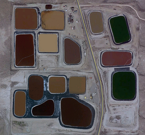
How To Find Wastewater Fracking Ponds Using Satellite Images

Wastewater Fracking Ponds

How To Find Waste Water Fracking Ponds Using Satellite Images

Due Diligence On Buying A Property Near Oil Well (15 Tips)

Due Diligence On Buying a property

When considering buying a property near an oil well, conducting thorough due diligence is crucial due to potential environmental and health considerations. 

Here are 15 key steps to take during the due diligence process: