Showing posts with label Earthquake. Show all posts

Leaked Memo Reveals $100M Emergency Funding Request to Tackle Texas Oil Well Blowouts and Contamination

blowout

Texas oil and gas regulators have requested over $100 million in emergency funding to address critical issues involving uncapped wells and oil field wastewater. According to a letter obtained by the Houston Chronicle, the Texas Railroad Commission (RRC), which oversees the state’s oil and gas industry, informed legislators that "emergent issues have developed" since the commission's annual budget request was filed on August 30.

In the letter, Danny Sorrells, Executive Director of the Railroad Commission, emphasized that the commission requires these additional funds to manage the increasing number of leaking wells. Without this financial boost, he warned, the state’s ability to safeguard groundwater from contamination would be compromised.

This urgent appeal follows a dramatic 100-foot geyser that erupted in a West Texas oil field, a region already experiencing earthquakes associated with wastewater injection. The incident raised concerns about the potential involvement of oil field wastewater and how it reached the site.

The commission stated that leaking and erupting wells are straining its current well-plugging budget, which limits efforts to preemptively plug wells before they begin leaking. The requested funds would help the commission stay ahead of these issues. "This is all part of our vigilant work to plug wells," the commission said in a follow-up statement.

This unexpected funding request highlights the escalating nature of well-related challenges in West Texas and marks a 72% increase in state funds sought for well plugging beyond what was initially budgeted. The commission’s original allocation included $234 million for well-plugging activities for 2026 and 2027, with $95 million sourced from federal funds provided by a Biden administration initiative.

The budget documentation noted that many Texas oil fields are aging, which heightens the risks posed by neglected or orphaned wells with no responsible owners to manage them. When owners abandon wells due to bankruptcy or company dissolution, the state inherits these liabilities. These wells can release wastewater to the surface, often necessitating emergency action. During fiscal year 2023, the commission spent nearly $10 million to plug 38 emergency wells. Lawmakers have been cautioned that additional funding will be essential to continue protecting the state’s groundwater effectively.

“The costs and number of emergency wells have increased sharply over the last several years,” the letter stated.

Additionally, the commission requested $2.7 million to employ 10 full-time staff to investigate the effects of wastewater injection, a byproduct of hydraulic fracturing (fracking), on underground formations. This team’s goal would be to identify “the root causes” of incidents like water blowouts and induced seismic activity.

A Legacy of Significant Concerns

This new investigative team would not be the first to address the impacts of oil industry wastewater on underground environments. Earlier this year, environmental organizations including Earthjustice, Commission Shift, and Clean Water Action petitioned the Environmental Protection Agency (EPA) to investigate Texas’ regulation of oil field wastewater and its "failure to protect drinking water."

In a response letter sent in May, the EPA acknowledged the petition's “substantial concerns” and stated that its regional office in Dallas would need time for a thorough review. More recently, the Environmental Integrity Project and Commission Shift sent another letter raising questions about discrepancies in Railroad Commission data on wastewater wells, underscoring the ongoing scrutiny of how these issues are managed in Texas.

Why Did Ojai Have a 5.0 Earthquake During Tropical Storm Hilary?

Ojai 5.0 earthquake near oil and gas wells

Did a massive amount of rainwater from Hurricane Hilary rush into the ground causing the first 5.0 earthquake?  16+ smaller earthquakes have followed so far

Denver Airport Oil & Gas Wells

Denver Airpot map of oil and gas wells

Denver, Colorado Airport Oil & Gas Wells Surround The Airport

Have you ever flown into Denver and wondered about all the oil and gas wells surrounding the airport?  We have mapped them using Google Satellite images.  How many of these wells are being fracked?  What effect do these wells have on the surrounding community's air quality?  Zoom into the airport using our Colorado Oil and Gas Wells Map.   

Denver International Airport (DIA) plans to permanently plug 64 idle oil and gas wells as part of its environmental sustainability plan. The airport plans to hire a contractor to plug the wells by late 2023 or early 2024.

The plugging process involves setting mechanical or cement plugs in the wellbore at specific intervals to prevent fluid flow. The process usually requires a workover rig and cement pumped into the wellbore. The plugging process can take two days to a week, depending on the number of plugs to be set in the well.

An oil or gas well is plugged and abandoned when it reaches the end of its useful life or becomes a dry hole. These operations include activities and tasks that present hazards to workers.

The airport holds 76 oil and gas wells on its property,   The airport generated $7M in oil revenue back in 2010.  

Colorado has an estimated 625 abandoned wells and as many as 19,000 oil and gas wells that produce less than two barrels of oil per day. The state's main oil- and natural gas-producing regions are the Denver Basin in northeastern Colorado and the Piceance Basin in western Colorado.

4.5 Earthquake in El Monte, CA Near Oil & Gas Fracking


It doesn't surprise me that fake news and seismologists' media will not mention that this earthquake site is right nearby and oil and gas fracking site.  Here is a link to the USGS Earthquake Map

4.5 magnitude earthquake hits San Gabriel Valley, with shaking felt throughout SoCal. An earthquake with a preliminary magnitude of 4.5 rattled Southern California Friday night, hitting near South El Monte with shaking felt in a wide swath of the region.

The USGS says the quake struck less than two miles west-southwest of South El Monte at 11:38 p.m., with a depth of about 10 miles.

Seismologist Dr. Lucy Jones told Eyewitness News the quake was similar in type and location to the deadly 1987 Whittier-Narrows quake, which had a magnitude of 5.9. But this one was much smaller in power.

She added that there were at least two aftershocks, measuring 2.1 and 1.6. She also said there is a 5% chance that it was a foreshock to a larger quake.

Of course, the press and the seismologist have no mention of the oil and gas relationship nearby.  See also LA Habra Drilling Maps. Were The La Habra Earthquakes Caused by Fracking Nearby?

Drilling Maps US

Abandoned Oil Well Blowout or Pipeline Break in Wilmington?

Wilmington oil spill map

Why Is Oil Seeping From Ground in Wilmington?  Why did they first think it was water?  

Later they realized it was an oil spill.  Is this from a blowout of an abandoned or capped well?  See full story on CBS LA

How Fracking Wastewater Taint Fresh Water Nearby

How Fracking Wastewater Taint Fresh Water Nearby

A study by the U.S. Geological Survey appears to have answered a critical question about the millions of gallons of chemical-laced water that are injected into the wells to fracture rocks and release trapped gas. Is there any cause for concern when that water is stored later, whether in treatment facilities or special underground wells?

Is SoCalGas Fracking in Play Vista, CA Causing Earthquakes?

Playa Del Rey Earthquakes from So Cal Gas Fracking

Is So Cal Gas Fracking in Play Del Rey?


Southern California Gas Company (SoCalGas) operates a natural gas storage facility in Playa Vista, Los Angeles, California. The facility is known as the Playa del Rey Gas Storage Field or the Playa Vista Storage Facility.

The Playa Vista Storage Facility is an underground natural gas storage site located in the Playa Vista neighborhood of Los Angeles. It is an important part of SoCalGas' natural gas infrastructure and plays a role in maintaining a reliable supply of natural gas to customers in the region.

It's worth noting that in addition to the Playa Vista facility, SoCalGas operates several other natural gas storage facilities and compressor stations throughout Southern California to ensure the distribution and delivery of natural gas to consumers.

Given the significance of natural gas infrastructure and its potential impact on the environment, companies like SoCalGas are required to adhere to stringent safety and regulatory standards. They continuously monitor their facilities, pipelines, and compressor stations to prevent methane leaks and ensure the safe and reliable operation of their natural gas infrastructure.

For specific details or updates regarding the Playa Vista SoCalGas facility or any other natural gas infrastructure in the area, it's best to reach out to SoCalGas directly or consult regulatory authorities responsible for overseeing natural gas operations in California.

If you have specific concerns or questions about methane and SoCalGas operations in Playa Del Rey, I recommend reaching out to SoCalGas directly or consulting regulatory authorities for the most up-to-date and accurate information on the company's activities and safety measures in the area.

Map of Frackquakes and Earthquakes

frackquakes map
500 3.0+ Earthquakes are now represented on DrillingMaps.com by teal dots to make the map easier to read.  Hopefully, this will make the map easier to read with other things alongside it. 

For "frackquakes," you can search for maps and data on induced seismicity related to hydraulic fracturing in specific regions. Some organizations and geological agencies may provide information on this topic. You can try searching for research papers, articles, or websites related to seismicity and hydraulic fracturing.

For natural earthquakes, you can find interactive earthquake maps from reputable sources such as the United States Geological Survey (USGS) or the European-Mediterranean Seismological Centre (EMSC). Both of these organizations offer real-time and historical earthquake data, including maps, which allow you to explore earthquake activity in various regions.

To access these maps, visit the respective websites of USGS (earthquake.usgs.gov) or EMSC (www.emsc-csem.org). From there, you can use their search tools or explore their earthquake maps to find the information you're interested in.

3.0+ Earthquakes in Oklahoma Map Since 2010

Map of 3.0+ Earthquakes in Oklahoma Since 2010
3.0+ Earthquakes in Oklahoma Since 2010

Oklahoma experienced a significant increase in seismic activity since 2010, particularly in the number of 3.0 magnitude or greater earthquakes. Many of these earthquakes have been linked to human activities, specifically wastewater injection related to oil and gas production.

Here are some of the notable 3.0+ earthquakes in Oklahoma from 2010 to date:

Magnitude 5.8 - September 3, 2016: This earthquake occurred near Pawnee, Oklahoma, and was the largest earthquake ever recorded in the state at that time.

Magnitude 5.7 - November 6, 2011: This earthquake struck near Prague, Oklahoma, and caused significant damage to homes and other structures.

Magnitude 5.6 - November 5, 2011: This earthquake also occurred near Prague, Oklahoma, the day before the 5.7 magnitude earthquake.

Magnitude 4.7 - November 12, 2011: This earthquake struck near Prague, Oklahoma, in the same region affected by the larger earthquakes earlier in November.

Magnitude 4.2 - January 18, 2011: This earthquake occurred near Jones, Oklahoma, and was widely felt in the Oklahoma City metropolitan area.

5.0+ Earthquakes Map since 2010

Map of 5.0+ Earthquakes since 2010

Here are some of the 5.0 magnitude or greater earthquakes that occurred in the lower 50 states of the United States since 2010:

Magnitude 5.8 - August 23, 2011: This earthquake occurred near Mineral, Virginia, and was widely felt along the East Coast of the United States, including states such as Virginia, Washington D.C., Maryland, and New York.

Magnitude 6.0 - August 24, 2014: This earthquake struck Napa Valley in Northern California and caused damage to buildings and infrastructure in the region.

Magnitude 6.5 - December 8, 2016: This earthquake occurred in the state of California, near Ferndale.

Magnitude 5.8 - September 22, 2020: This earthquake struck near Lone Pine, California, in the eastern Sierra Nevada region.

 There may have been additional earthquakes with a magnitude of 5.0 or greater since my last update. For the most current information, I recommend checking with the United States Geological Survey (USGS) or other reliable sources that provide real-time earthquake data.

3.0+ Earthquakes Map Since 2010

Map of 3.0+ Earthquakes Since 2010 from USGS

Here are some of the largest earthquakes to occur in the United States since 2010:

Magnitude 9.1 - March 11, 2011: This earthquake occurred off the coast of Tohoku, Japan, but it generated a tsunami that affected the west coast of the United States, causing damage in areas like California and Oregon.

Magnitude 7.8 - November 30, 2018: This earthquake struck near Anchorage, Alaska, causing significant damage to infrastructure and buildings in the region.

Magnitude 7.1 - July 5, 2019: This earthquake occurred in Ridgecrest, California, and was part of a larger seismic sequence that included a magnitude 6.4 foreshock.

Magnitude 7.0 - November 30, 2018: This earthquake also occurred near Anchorage, Alaska, and was a part of the same seismic sequence as the magnitude 7.8 mentioned earlier.

Magnitude 6.9 - August 24, 2014: This earthquake struck off the coast of Northern California near Napa Valley and caused damage to buildings, particularly in the town of Napa.

For the most current information, I recommend checking with the United States Geological Survey (USGS) or other reliable sources that provide real-time earthquake data.

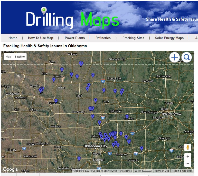
Oklahoma Oil & Gas Drilling Induced Earthquakes Map

5.7 Oklahoma Oil & Gas Drilling Earthquake Map
5.7 Oklahoma Oil & Gas Drilling Earthquake Map
Drilling-induced earthquakes may endanger millions in 2016, USGS says

Wasco, California 4.9 Earthquake Near Fracking Sites

Wasco, California 4.9 Earthquake Near Fracking Sites

Greeley Colorado 3.7 Earthquake From Fracking?

Greeley Colorado 3.7 Earthquake
Did Fracking Cause This Colorado Earthquake

Texas Earthquakes from Fracking?

Texas Earthquakes Map from Fracking?
The topic of induced earthquakes related to hydraulic fracturing, commonly known as fracking, has been a subject of research and concern in various regions, including Texas. Hydraulic fracturing is a technique used to extract oil and gas from underground rock formations by injecting fluids at high pressure to create fractures and release the trapped resources.

While most hydraulic fracturing operations do not cause significant seismic activity, some instances have been associated with induced earthquakes. The process of injecting fluids into the ground can increase pore pressure in the subsurface and potentially reactivate pre-existing faults, leading to seismic events.

In Texas, there have been reports of earthquakes linked to hydraulic fracturing activities, particularly in regions with increased fracking operations. However, it's essential to note that the number of induced earthquakes related to fracking in Texas has been relatively small compared to naturally occurring earthquakes.

The Texas Railroad Commission, which regulates oil and gas operations in the state, has been monitoring seismic activity and its potential link to fracking activities. The commission has implemented measures to address induced seismicity, such as issuing disposal well permits more cautiously in areas with higher seismic risks.

Researchers and geological agencies continuously study the relationship between fracking and induced earthquakes to better understand the potential risks and to develop appropriate regulatory measures to minimize seismic hazards.

Ohio Earthquakes from Fracking?

Ohio Earthquakes Map from Fracking

Map of Ohio showing earthquakes near oil wells. 


Oklahoma Earthquakes from Fracking?

Are These 3.0+ Earthquakes in Oklahoma From Fracking?