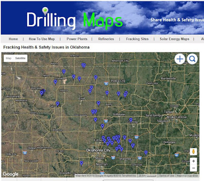
Map of Frackquakes and Earthquakes

frackquakes map
500 3.0+ Earthquakes are now represented on DrillingMaps.com by teal dots to make the map easier to read.  Hopefully, this will make the map easier to read with other things alongside it. 

For "frackquakes," you can search for maps and data on induced seismicity related to hydraulic fracturing in specific regions. Some organizations and geological agencies may provide information on this topic. You can try searching for research papers, articles, or websites related to seismicity and hydraulic fracturing.

For natural earthquakes, you can find interactive earthquake maps from reputable sources such as the United States Geological Survey (USGS) or the European-Mediterranean Seismological Centre (EMSC). Both of these organizations offer real-time and historical earthquake data, including maps, which allow you to explore earthquake activity in various regions.

To access these maps, visit the respective websites of USGS (earthquake.usgs.gov) or EMSC (www.emsc-csem.org). From there, you can use their search tools or explore their earthquake maps to find the information you're interested in.

3.0+ Earthquakes in Oklahoma Map Since 2010

Map of 3.0+ Earthquakes in Oklahoma Since 2010
3.0+ Earthquakes in Oklahoma Since 2010

Oklahoma experienced a significant increase in seismic activity since 2010, particularly in the number of 3.0 magnitude or greater earthquakes. Many of these earthquakes have been linked to human activities, specifically wastewater injection related to oil and gas production.

Here are some of the notable 3.0+ earthquakes in Oklahoma from 2010 to date:

Magnitude 5.8 - September 3, 2016: This earthquake occurred near Pawnee, Oklahoma, and was the largest earthquake ever recorded in the state at that time.

Magnitude 5.7 - November 6, 2011: This earthquake struck near Prague, Oklahoma, and caused significant damage to homes and other structures.

Magnitude 5.6 - November 5, 2011: This earthquake also occurred near Prague, Oklahoma, the day before the 5.7 magnitude earthquake.

Magnitude 4.7 - November 12, 2011: This earthquake struck near Prague, Oklahoma, in the same region affected by the larger earthquakes earlier in November.

Magnitude 4.2 - January 18, 2011: This earthquake occurred near Jones, Oklahoma, and was widely felt in the Oklahoma City metropolitan area.

5.0+ Earthquakes Map since 2010

Map of 5.0+ Earthquakes since 2010

Here are some of the 5.0 magnitude or greater earthquakes that occurred in the lower 50 states of the United States since 2010:

Magnitude 5.8 - August 23, 2011: This earthquake occurred near Mineral, Virginia, and was widely felt along the East Coast of the United States, including states such as Virginia, Washington D.C., Maryland, and New York.

Magnitude 6.0 - August 24, 2014: This earthquake struck Napa Valley in Northern California and caused damage to buildings and infrastructure in the region.

Magnitude 6.5 - December 8, 2016: This earthquake occurred in the state of California, near Ferndale.

Magnitude 5.8 - September 22, 2020: This earthquake struck near Lone Pine, California, in the eastern Sierra Nevada region.

 There may have been additional earthquakes with a magnitude of 5.0 or greater since my last update. For the most current information, I recommend checking with the United States Geological Survey (USGS) or other reliable sources that provide real-time earthquake data.

3.0+ Earthquakes Map Since 2010

Map of 3.0+ Earthquakes Since 2010 from USGS

Here are some of the largest earthquakes to occur in the United States since 2010:

Magnitude 9.1 - March 11, 2011: This earthquake occurred off the coast of Tohoku, Japan, but it generated a tsunami that affected the west coast of the United States, causing damage in areas like California and Oregon.

Magnitude 7.8 - November 30, 2018: This earthquake struck near Anchorage, Alaska, causing significant damage to infrastructure and buildings in the region.

Magnitude 7.1 - July 5, 2019: This earthquake occurred in Ridgecrest, California, and was part of a larger seismic sequence that included a magnitude 6.4 foreshock.

Magnitude 7.0 - November 30, 2018: This earthquake also occurred near Anchorage, Alaska, and was a part of the same seismic sequence as the magnitude 7.8 mentioned earlier.

Magnitude 6.9 - August 24, 2014: This earthquake struck off the coast of Northern California near Napa Valley and caused damage to buildings, particularly in the town of Napa.

For the most current information, I recommend checking with the United States Geological Survey (USGS) or other reliable sources that provide real-time earthquake data.