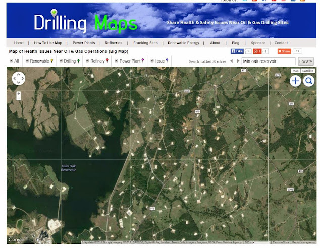
Using satellite images to identify oil and gas well pads is a technique employed by various stakeholders in the industry.
Satellite imagery provides a valuable tool for monitoring and assessing oil and gas activities from a remote perspective. By analyzing these images, experts can detect well pads and associated infrastructure, observe changes over time, and gather valuable information about the extent of oil and gas operations.
Satellite images offer a bird's-eye view of the Earth's surface, capturing detailed information about land use, infrastructure, and geological features. With advancements in technology, high-resolution satellite imagery has become more accessible, allowing for more accurate and precise identification of well pads. These images can reveal the physical characteristics of well pads, such as their size, shape, and proximity to other structures.
To identify oil and gas well pads from satellite images, analysts look for specific visual cues. Well pads typically exhibit distinct characteristics, such as cleared areas, compacted surfaces, and a cluster of equipment and facilities. These features, along with the presence of access roads and pipelines, can help differentiate well pads from other land uses.
Sophisticated image analysis techniques, including machine learning algorithms, are often employed to automate the process of identifying well pads from satellite images. These algorithms can be trained to recognize patterns associated with oil and gas infrastructure, increasing the efficiency and accuracy of the identification process.
Various entities utilize satellite imagery to monitor oil and gas activities, including regulatory agencies, environmental organizations, and companies in the energy sector. By observing well pad locations, their expansion, and potential environmental impacts, stakeholders can make informed decisions, conduct assessments, and ensure compliance with regulations.
It's important to note that access to high-quality satellite imagery may be subject to certain restrictions and limitations. Additionally, while satellite images can provide valuable insights, ground-level verification and other data sources are often necessary for a comprehensive understanding of oil and gas operations in a particular area.
